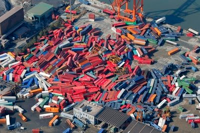
While watching the destruction caused by the tsunami in Japan,
I realized how little I know of the topography of Japan.
Most of us have seen the pictures of destroyed cities,
but may not realize this is along an almost 400 mile coastline,
not just an isolated section,
covering at least 5 "states" or prefectures of Japan,
On this map,
its #'s - 3 - Aomori, 16 - Iwate, 24 - Miyagi, 8 - Fukushima, 14 - Ibaraki.
A long stretch of the north eastern part of Honshu Island.
Incredible the amount of force needed for this level of destruction.
You see these pics of large ships sitting far inland.
The kids were wondering how they ended up there.
News Video - West TV - The West Australian
Supposedly the wall of water was at least 34 feet tall!
wow
Just watching this video is mesmerizing.
Not much I can write that it doesn't show.
I realized how little I know of the topography of Japan.
Most of us have seen the pictures of destroyed cities,
but may not realize this is along an almost 400 mile coastline,
not just an isolated section,
covering at least 5 "states" or prefectures of Japan,
On this map,
its #'s - 3 - Aomori, 16 - Iwate, 24 - Miyagi, 8 - Fukushima, 14 - Ibaraki.
A long stretch of the north eastern part of Honshu Island.
 |
| Minamisanriku - Miyagi prefecture |
Incredible the amount of force needed for this level of destruction.
You see these pics of large ships sitting far inland.
 |
| Otsuchi, Iwate Prefecture |
The kids were wondering how they ended up there.
News Video - West TV - The West Australian
 |
| Kesennuma, Miyagi Prefecture |
Supposedly the wall of water was at least 34 feet tall!
 |
| Sendai, Miyagi Prefecture |
wow
 |
| Hachinohe, Aomori Prefecture |
Just watching this video is mesmerizing.
Not much I can write that it doesn't show.
Just puts the issues in our lives in a different perspective.
 |
| Tokai Village, Ibaraki Prefecture |
Sad to see how many lives are effected,
not to mention the nuclear threat.
Simple things like food, water, shelter, power, sewage...
 |
| Rikuzentakata - Iwate Prefecture |
I've found there is alot of information and videos from RUSSIA TODAY.
RT
There YOUTUBE channel is way more thorough than America's repetitive CNN.
YouTube - RussiaToday's Channel
Nice that its in English.
Thoughts and prayers go out to the Japanese people.
TP

No comments:
Post a Comment